Resource Estimation in GEOVIA Surpac Using Geostatistics

- A V N SASTRY
- July 4, 2025
Resource estimation is the process of quantifying the amount and grade of mineral resources within a geological deposit. It forms the foundation for feasibility studies, mine design, and financial modeling. Inaccurate estimates can lead to poor investment decisions, operational inefficiencies, and regulatory challenges. Therefore, mining professionals increasingly rely on sophisticated tools like Surpac to ensure precision and transparency.
Why Choose GEOVIA Surpac?
GEOVIA Surpac is one of the most widely used geological modeling and mine planning software platforms in the world. It supports a range of functionalities including:
– Drillhole data management
– Geological interpretation
– Block modeling
– Grade estimation
– Pit design and scheduling
Its user-friendly interface, powerful 3D visualization capabilities, and integration with geostatistical tools make it ideal for both exploration geologists and mining engineers.
Integrating Geostatistics: A Game-Changer
Geostatistics is a branch of statistics that deals with spatially correlated data. In resource estimation, it allows professionals to model the spatial distribution of grades and quantify uncertainty. Techniques such as variogram modeling, kriging, and simulation are central to this approach.
Benefits of Geostatistical Estimation:
– Improved Accuracy: Kriging provides the best linear unbiased estimate (BLUE) of unknown values.
– Quantification of Uncertainty: Helps in risk assessment and classification of resources.
– Spatial Continuity: Captures geological trends and anisotropy effectively.
Workflow: Resource Estimation in Surpac Using Geostatistics
1. Data Preparation
The process begins with importing and validating drillhole data. This includes assays, lithology, survey data, and coordinates. Ensuring data integrity is critical before proceeding to modeling.
2. Compositing
Samples are composited to a consistent length to reduce bias. Surpac allows flexible compositing based on lithological boundaries or fixed intervals.
3. Exploratory Data Analysis (EDA)
EDA involves statistical analysis of the data to understand distribution, detect outliers, and identify geological domains. Histograms, scatter plots, and log probability plots are commonly used.
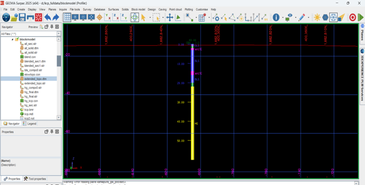
4. Variography
Variograms are used to model spatial continuity. Surpac supports experimental variogram generation and fitting of theoretical models (e.g., spherical, exponential). Directional variograms help identify anisotropy, which is crucial for accurate estimation.
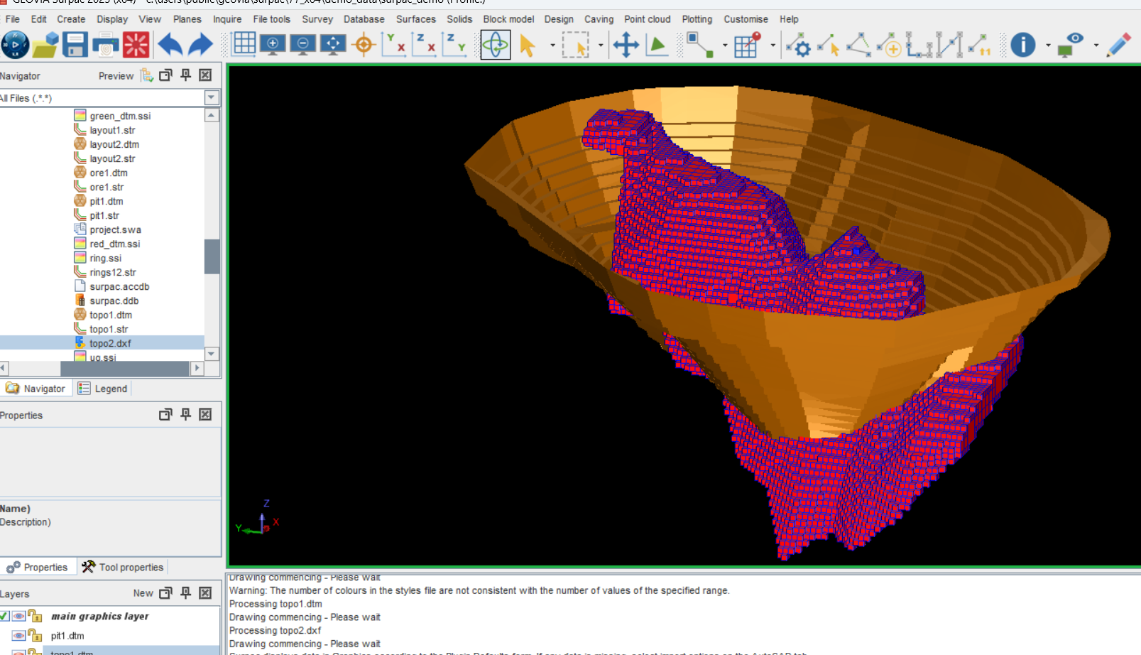
5. Block Model Construction
A 3D block model is created to represent the deposit. Parameters such as block size, extents, and sub-blocking are defined. Geological attributes and constraints are assigned to each block.

6. Estimation Using Kriging or ISD (Inverse Square Distance)
Kriging is the most widely used geostatistical method in Surpac. It uses the variogram model to interpolate grades into the block model. Other methods like Inverse Distance Weighting (IDW) or Co-Kriging can also be applied depending on the data and objectives.
7. Ellipsoid Search Parameters
Estimation ellipsoids define the search neighborhood for kriging. They are oriented based on geological structures and variogram directions. Surpac allows customization of ellipsoid dimensions and orientations to reflect geological anisotropy.
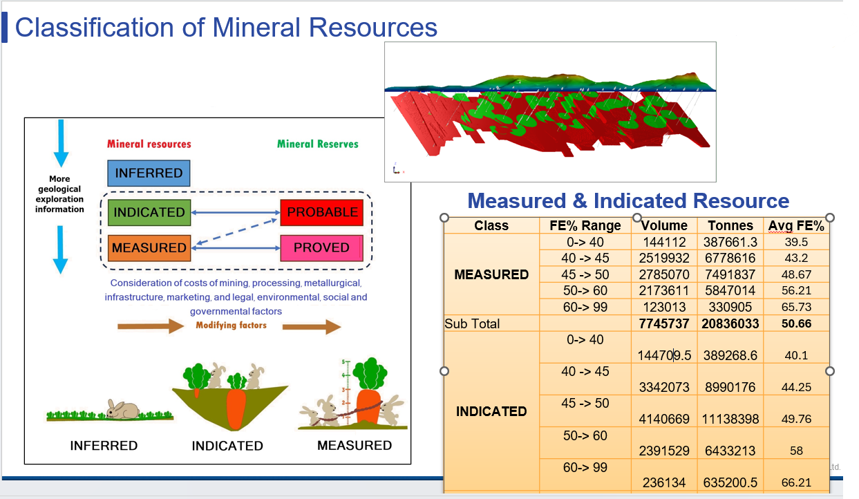
8. Validation and Classification
The model is validated using cross-validation, swath plots, and comparison with raw data. Resources are then classified into Measured, Indicated, and Inferred categories based on data density and estimation confidence.

9. Visualization and Reporting
Surpac’s 3D visualization tools enable professionals to view block models, grade shells, and estimation ellipsoids interactively. Reports can be generated for tonnage, grade, and classification summaries.
Promoting Best Practices in Resource Estimation
To maximize the benefits of Surpac and geostatistics, professionals should adhere to the following best practices:
– Use domain-specific variograms: Avoid applying a single model across geologically distinct zones.
– Validate at every step: Ensure consistency between input data, variograms, and estimation results.
– Document assumptions: Maintain transparency for audits and compliance.
– Collaborate across disciplines: Integrate geological, geotechnical, and metallurgical insights.
Conclusion: A Strategic Advantage
In today’s competitive mining landscape, the ability to produce accurate and auditable resource estimates is a strategic advantage. GEOVIA Surpac, when combined with geostatistical methods, empowers professionals to model complex deposits with confidence. From exploration to production, this integrated approach enhances decision-making, reduces risk, and supports sustainable resource development.
Whether you are a geologist, mining engineer, or resource analyst, mastering Surpac and geostatistics is an investment in precision, professionalism, and performance.

Recent Posts
-

Enhancing Product Understanding through 3D Technical Illustrator
The 3D Technical Illustrator role within the 3DEXPERIENCE Platform enables organizations to transform complex engineering data into clear, interactive, and visually rich technical documentation. In…
-

Transforming Physical Parts into Digital Models with CATIA 3DEXPERIENCE Reverse Engineer role
Reverse engineering has become a critical capability in modern product development, especially when working with legacy components, competitor benchmarking, or physical prototypes that lack digital…
-

Fixing Search Service Down Issue in 3DEXPERIENCE Platform
Search is one of the most critical features in the 3DEXPERIENCE platform. If the search service goes down, users cannot find objects, documents, or data—impacting…
-
Common Installation Errors and How to Fix Them in 3DEXPERIENCE
The 3DEXPERIENCE Platform is a powerful solution used by industries worldwide for product lifecycle management (PLM), simulation, and collaboration. However, installing 3DEXPERIENCE—especially on-premise—can be complex…
-

From Classroom to Industry: Empowering Future Engineers with the 3DEXPERIENCE Platform
In today’s fast-evolving engineering and design landscape, educational institutions must go beyond conventional CAD teaching methods. While standalone tools like CATIA V5, SOLIDWORKS, or traditional…
-
CATIA Composer – Transforming Engineering Data into Interactive Technical Documentation
CATIA Composer is a powerful desktop application from Dassault Systemes designed to transform engineering 3D CAD data into highly intuitive and interactive technical documentation. In…
-
3DEXPERIENCE CATIA Composite Design – Delivering Next-Generation Precision for Advanced Composite Structures
3DEXPERIENCE CATIA Composite Design is an advanced, collaborative, and highly integrated engineering solution designed to manage the complexity of modern composite structures used across aerospace,…
-

Keysight Optical Simulation Solutions: Innovation in Optical Design
Leveraging Keysight’s portfolio of optical and photonic design and simulation software one can accurately model all facets of an optical system. These advanced and interactive…
- A V N SASTRY
- July 4, 2025
Resource Estimation in GEOVIA Surpac Using Geostatistics
Resource estimation is the process of quantifying the amount and grade of mineral resources within a geological deposit. It forms the foundation for feasibility studies, mine design, and financial modeling. Inaccurate estimates can lead to poor investment decisions, operational inefficiencies, and regulatory challenges. Therefore, mining professionals increasingly rely on sophisticated tools like Surpac to ensure precision and transparency.
Why Choose GEOVIA Surpac?
GEOVIA Surpac is one of the most widely used geological modeling and mine planning software platforms in the world. It supports a range of functionalities including:
– Drillhole data management
– Geological interpretation
– Block modeling
– Grade estimation
– Pit design and scheduling
Its user-friendly interface, powerful 3D visualization capabilities, and integration with geostatistical tools make it ideal for both exploration geologists and mining engineers.
Integrating Geostatistics: A Game-Changer
Geostatistics is a branch of statistics that deals with spatially correlated data. In resource estimation, it allows professionals to model the spatial distribution of grades and quantify uncertainty. Techniques such as variogram modeling, kriging, and simulation are central to this approach.
Benefits of Geostatistical Estimation:
– Improved Accuracy: Kriging provides the best linear unbiased estimate (BLUE) of unknown values.
– Quantification of Uncertainty: Helps in risk assessment and classification of resources.
– Spatial Continuity: Captures geological trends and anisotropy effectively.
Workflow: Resource Estimation in Surpac Using Geostatistics
1. Data Preparation
The process begins with importing and validating drillhole data. This includes assays, lithology, survey data, and coordinates. Ensuring data integrity is critical before proceeding to modeling.
2. Compositing
Samples are composited to a consistent length to reduce bias. Surpac allows flexible compositing based on lithological boundaries or fixed intervals.
3. Exploratory Data Analysis (EDA)
EDA involves statistical analysis of the data to understand distribution, detect outliers, and identify geological domains. Histograms, scatter plots, and log probability plots are commonly used.
4. Variography
Variograms are used to model spatial continuity. Surpac supports experimental variogram generation and fitting of theoretical models (e.g., spherical, exponential). Directional variograms help identify anisotropy, which is crucial for accurate estimation.
5. Block Model Construction
A 3D block model is created to represent the deposit. Parameters such as block size, extents, and sub-blocking are defined. Geological attributes and constraints are assigned to each block.
6. Estimation Using Kriging or ISD (Inverse Square Distance)
Kriging is the most widely used geostatistical method in Surpac. It uses the variogram model to interpolate grades into the block model. Other methods like Inverse Distance Weighting (IDW) or Co-Kriging can also be applied depending on the data and objectives.
7. Ellipsoid Search Parameters
Estimation ellipsoids define the search neighborhood for kriging. They are oriented based on geological structures and variogram directions. Surpac allows customization of ellipsoid dimensions and orientations to reflect geological anisotropy.
8. Validation and Classification
The model is validated using cross-validation, swath plots, and comparison with raw data. Resources are then classified into Measured, Indicated, and Inferred categories based on data density and estimation confidence.
9. Visualization and Reporting
Surpac’s 3D visualization tools enable professionals to view block models, grade shells, and estimation ellipsoids interactively. Reports can be generated for tonnage, grade, and classification summaries.
Promoting Best Practices in Resource Estimation
To maximize the benefits of Surpac and geostatistics, professionals should adhere to the following best practices:
– Use domain-specific variograms: Avoid applying a single model across geologically distinct zones.
– Validate at every step: Ensure consistency between input data, variograms, and estimation results.
– Document assumptions: Maintain transparency for audits and compliance.
– Collaborate across disciplines: Integrate geological, geotechnical, and metallurgical insights.
Conclusion: A Strategic Advantage
In today’s competitive mining landscape, the ability to produce accurate and auditable resource estimates is a strategic advantage. GEOVIA Surpac, when combined with geostatistical methods, empowers professionals to model complex deposits with confidence. From exploration to production, this integrated approach enhances decision-making, reduces risk, and supports sustainable resource development.
Whether you are a geologist, mining engineer, or resource analyst, mastering Surpac and geostatistics is an investment in precision, professionalism, and performance.