Efficient Land Data & Workflow Management with GIS
- admin_eds
- September 18, 2024
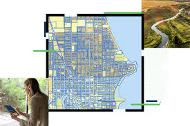
GIS applications are instrumental in land management systems, supporting cadastral mapping, land use planning, environmental assessment, natural resource management, transaction management, risk assessment, and decision support. By leveraging GIS technology, land managers can streamline processes, enhance data analysis, and improve the overall efficiency and effectiveness of land-related operations. There are specific applications designed for land management systems. These applications provide comprehensive tools and functionalities to effectively manage land-related data, processes, and workflows.

Recent Posts
-

From Repair to Rapid Prototyping: The Role of LENS DED Technology in Aerospace Industry
What is Lens DED Technology? Lens DED (Laser Engineered Net Shaping Directed Energy Deposition) is an advanced additive manufacturing process that uses a high-power laser…
-

Shaping the Future of Automotive Lighting with Advanced Simulation
In today’s modern automotive sector, headlamps have evolved into distinctive design elements that contribute significantly to a vehicle's overall aesthetic. Each brand strives for a…
-

Classification of Industrial Additive Manufacturing (AM)
Classification based on the overall Landscape of Additive Manufacturing The AM is broadly classified into 2 categories: Technology Materials Figure (1): Classification based on…
-

A Unique Revolution: Manufacturing Tire Sipes with EOS DMLS and the M290 System
In the tire industry, precision and efficiency are paramount when producing high-quality tires that perform optimally on the road. With increasing pressure to innovate while…
-

Innovating Design in the Space Industry with 3DEXPERIENCE CATIA
The space industry is at the forefront of technological advancement, with its unique challenges demanding cutting-edge tools for design and engineering. From satellites and spacecraft…
-

Enhancing Semiconductor Design with EDA Tools and Solutions
Overview The semiconductor industry demands cutting-edge tools to address the complexities of modern chip design. As a trusted partner, EDS Technologies supports the adoption of…
-

Game Changing EOS Systems for Lifestyle and Consumer Goods Industry: Eyewear Applications
Every person’s face is as unique as their personality, making custom eyewear not just a luxury but a necessity for optimal comfort and functionality. Traditional…
-

Reinventing the Automotive Supply Chain with the Digital Experience Platform
Increased product complexity, global sourcing & disruptions, uncertainty, sustainability and regulatory pressures, consumer demand shifts, and cost pressures are some of the significant challenges that…
- admin_eds
- September 18, 2024
Efficient Land Data & Workflow Management with GIS
GIS applications are instrumental in land management systems, supporting cadastral mapping, land use planning, environmental assessment, natural resource management, transaction management, risk assessment, and decision support. By leveraging GIS technology, land managers can streamline processes, enhance data analysis, and improve the overall efficiency and effectiveness of land-related operations. There are specific applications designed for land management systems. These applications provide comprehensive tools and functionalities to effectively manage land-related data, processes, and workflows.