|
VT MAK is pleased to announce the release of VR-Forces 4.7!
This major feature release adds many new features, while continuing to make significant improvements to our visuals, performance, and content.
Modeling:
- People can be tasked to enter and leave vehicles realistically.
- Satellites can now be simulated in VR-Forces with orbital motion and an Earth Centered Inertial model. Satellites and other objects can be quickly created by loaded TLE (Two Line Element) files.
- IFF codes can be configured to change periodically and automatically at specified intervals for appropriately configured aircraft.
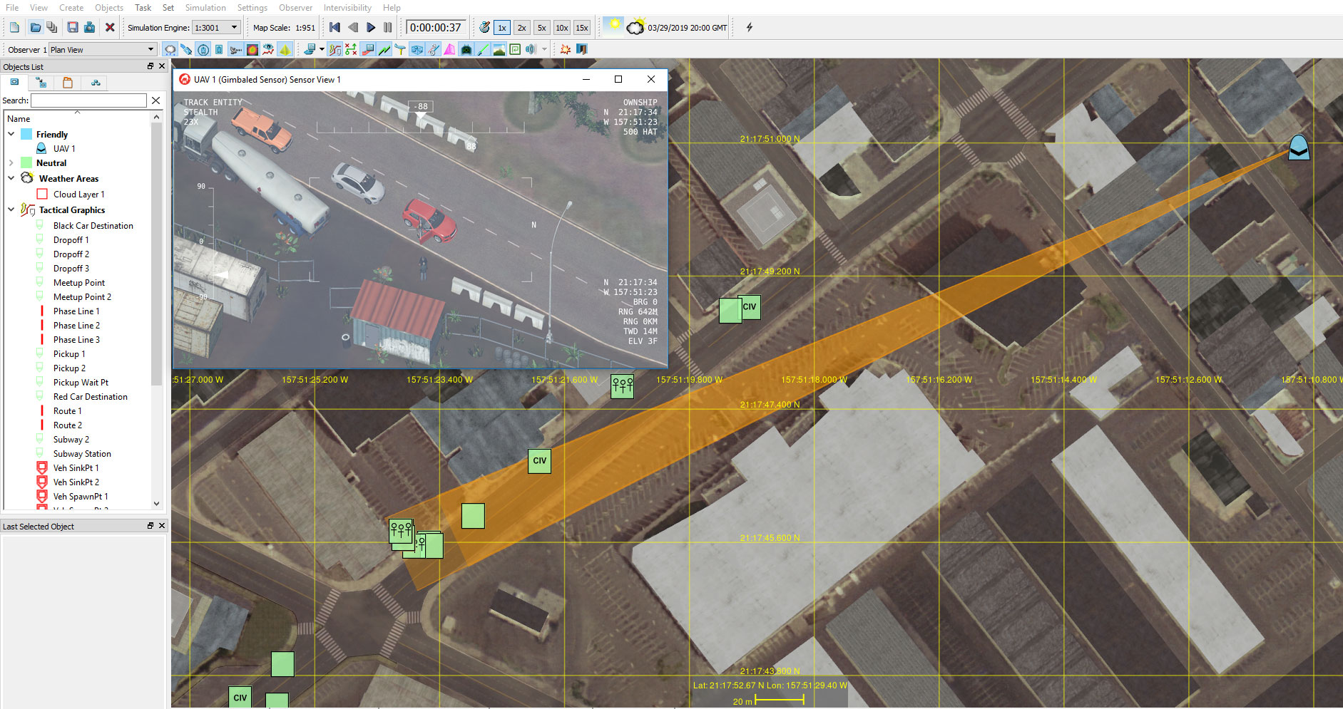
- Air assets can be tasked to orbit and track a ground vehicle for easier ISR tasking.
- A primitive ballistic missile model has been added; this low fidelity model allows objects to track a parabolic arc across the globe.
Aggregate Level Simulation:
- Updated air-to-air combat model.
- Updated surface-to-air combat model.
- Calculation of fuel use based on altitude and speed.
- New concepts of airframe and loadout for air units.
- Air bases, with full logistics, personnel, runway availability and damage modeling.
- Midair refueling capabilities.
- Enhanced radar and IFF.
Weather Simulation:
Create localized cloud layers which will be visualized in VR-Vantage.
Easier Configuration:
- The Simulation Object Editor (SOE) has been completely
 rewritten to make configuring entities much easier and more intuitive. The SOE lets users graphically configure PH (Probability of Hit) and PK (Probability of Kill) tables by simply clicking and dragging a chart. rewritten to make configuring entities much easier and more intuitive. The SOE lets users graphically configure PH (Probability of Hit) and PK (Probability of Kill) tables by simply clicking and dragging a chart.
- The Simulation Object Editor now allows users to graphically display PK charts between any two entities. Users can quickly see why entity A cannot hit entity B and make adjustments on the fly.
Performance Improvements:
Long distance intersections – such as between space and the earth, or from an aircraft to points over the horizon – are now extremely fast with paged terrains.
Terrain Improvements:
- VR-Forces vehicles can now plan paths along roads specified by linear features served from a VR-The World Server.
- VR-Forces can load and simulate on EGM (Earth Gravitational Model) elevation data. .
- Support for building Navigation Meshes for extremely deep or extremely high terrains (tunnels and very tall buildings). .
- Users can now generate new navigation paths that don’t require matching terrain – users can create tunnels and crawl spaces in their terrain that are not part of the modeled database. This allows people to generate tunnels where none previously existed. .
- To make terrain configuration easier, props can be exported to shapefiles.
Battlefield Planning:
- Airspace Control Orders (ACOs) can now be loaded and VR-Forces can generate tactical graphics from them.
- Visualization of radar coverage in 2D and 3D, for customers wishing to plan ground based anti-air radar coverage areas.
|